
SIR CREEK & PRESENT DEVELOPMENT
SARASIJ MAJUMDER
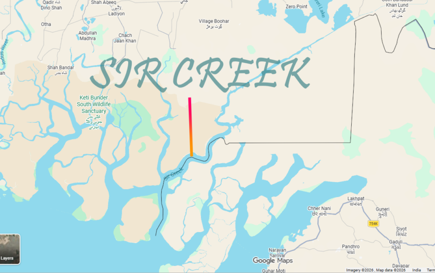
Sir Creek, originally known as ‘BAN GANGA’, is a 96 km tidal estuary in the uninhabited marshlands of the Indus River Delta on the border between India and Pakistan. The creek flows into the Arabian Sea and separates Gujarat state in India from Sindh province in Pakistan.
The dispute originated during British Period of India. During the British period, the entire region was part of the Bombay Presidency, which included the present-day Maharashtra & Gujarat of India and Sindh of Pakistan.
The 1914 Bombay Government Resolution (officially Resolution No. 1192) is the foundational colonial-era document at the heart of the ongoing Sir Creek border dispute between India and Pakistan. Originally passed by the British-administered Bombay Presidency, the resolution attempted to formalize the boundary between the Princely State of Kutch (now part of Gujarat, India) and the Sindh Province (now part of Pakistan). Because the text contains internal contradictions, both nations interpret it differently to claim sovereignty over the 96-kilometer tidal estuary.
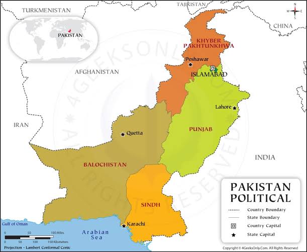
After Partition in 1947, Sindh became part of Pakistan while Kutch remained with India.
Origin of the Dispute: The Firewood Spark (1908): The dispute began over a localized conflict regarding rights to collect firewood from the marshy creek area between the Rao of Kutch and the Sindh provincial government. The Compromise (1914): The Government of Bombay stepped in to arbitrate. Kutch agreed to give up its claims to nearby Kori Creek in exchange for a finalized border delineation around Sir Creek.
The Contradictory Clauses: The structural ambiguity of the 1914 Resolution lies within two critical paragraphs:
Paragraph 9 (The “Green Line”): This section indicates that the boundary lies along the eastern bank of Sir Creek. This interpretation awards the entirety of the water body to Sindh (Pakistan).
Paragraph 10 (The Navigability Rule): This section notes that Sir Creek is navigable for most of the year. Under international maritime custom, navigable waterways are split down the center—a legal concept known as the Thalweg Principle.
The core of the dispute was and is about where to draw the boundary.
Pakistan claims the entire creek, citing clause 9 of 1914 Bombay Government Resolution, that established the boundary along the eastern bank — the so-called Green Line — effectively placing the creek in Sindh. India argues for the mid-channel principle, i.e. Clause No.10– backed by a 1925 map and the internationally accepted Thalweg principle, which says that the border between two nations sharing a navigable waterway should run along the deepest channel. India maintains that Sir Creek navigable most of the year, and so the boundary should run through the middle. Pakistan disputes this, insisting that the creek is not navigable throughout the year.
If we apply ‘ETMOLOGY‘ on ‘Ban- Ganga’ name—possibly it implies that the Creek becomes ‘GANGA’—meaning a MAJOR RIVER, during ‘BAN’ meaning TIDE.
MILITARY IMPORTANCE:
The military importance of Sir Creek lies primarily in its strategic role as a vital buffer zone that dictates maritime boundaries, controls access to a key Pakistani naval hub and presents high-stakes unconventional security challenges for both India and Pakistan. This 96-kilometer-long tidal estuary separating Gujarat (India) from Sindh (Pakistan) serves as a sensitive front line.
Proximity to Karachi and Operational Vulnerability–Gateway to Karachi: Sir Creek is situated just southeast of Karachi, Pakistan’s largest city, primary commercial hub, and essential naval base.
Target & Defense Line: For Pakistan, maintaining a heavy defensive posture in Sir Creek is crucial for preventing a seaward or amphibious flanking maneuvers by the Indian Navy during a conflict. For India, a strong military presence provides a direct leverage point overlooking Pakistan’s maritime nerve center.
Prevention of Cross-Border Infiltration & Terrorism Launchpad for Subversion: The creek’s complex web of mangrove thickets, marshes, and shifting water channels makes visual surveillance exceptionally difficult, rendering it a high-risk route for hybrid warfare.
Historical Precedent: The 2008 Mumbai terror attack exploited the regional maritime boundary gap when Pakistani terrorists hijacked an Indian fishing trawler near this zone to infiltrate Indian waters.
Critical Choke Points: Specific channels like Harami Nala ( I was involved from 2009-2011 about organizing defense of it) and Bondho Dhoro are heavily guarded by India to stop tactical incursions, small-unit raids, and the smuggling of narcotics or weapons.
Delimitation of the Exclusive Economic Zone (EEZ)Resource Ownership: The final boundary line in the creek dictates how the maritime border extends 200 nautical miles into the Arabian Sea.
Strategic Energy Reserves: The disputed offshore seabed is believed to contain vast, untapped oil and natural gas deposits. Controlling the creek translates directly to securing sovereign rights over these critical energy assets.
Risk of a Multi-Front War- Alignment, Force Overstretch: Military analysts emphasize that any flare-up or exploitation of Sir Creek by Pakistan could force India to stretch its armed forces across a new southern axis, adding to existing pressures along the Line of Control (LoC) in Kashmir and the desert borders of Rajasthan.
———————————————————————————————
ARABIAN SEA
|
| [ PAKISTAN (Sindh) ] [ INDIA (Gujarat) ] |
| • Marine Security Posts • Floating Border |
| • Air Défense Upgrades Posts (BSF) |
| • Forward Bases & Radars • Creek Crocodile |
| Commandos |
| \ / |
| \ / |
| SIR CREEK |
| (96-km Disputed Tidal Estuary) |
| || |
| || |
| [ Harami Nala ] |
| (Critical Infiltration Corridor) |
——————————————————————————————————-
TACTICAL DEPLOYMENTS:
Both nations have significantly fortified their presence to counter the rugged terrain:
India’s Défense Mechanism: Guarded by the Border Security Force (BSF) using floating border outposts and the specialised Creek Crocodile Commandos, who are trained for amphibious and marshy operations. The Indian Coast Guard mans the immediate coastline, while the Indian Navy patrolled the outer open waters.
Pakistan’s Défense Mechanism: Pakistan has integrated its army and naval presence through dedicated creek battalions, coastal Défense units, and hardened bunkers equipped with radar systems and drone operations. Recent developments indicate an upgraded focus on coastal rocket forces and marine security posts near the Harami Dhoro area.
Control of the Sir Creek area provides a significant strategic advantage, enabling India to maintain a military presence on its western part near Kach. However, Mangrove thickets and shifting channels provide natural cover for infiltration, smuggling, and small unit raids by Pakistan.
ECONOMIC VALUE:
The creek itself is of enormous economic importance. The definition of the International Boundary at Sir Creek has a direct impact on the delimitation of both countries’ Exclusive Economic Zones (EEZs) in the Arabian Sea. The EEZs extend up to 200 nautical miles (370.4 km) beyond a nation’s territorial waters, within which it has jurisdiction over living and non-living resources.
Apart from the EEZs, control over the Creek would influence the delimitation of maritime boundaries, including continental shelves, which are crucial for oil and gas exploration. The region is believed to have reserves of both, and fishing rights are also a sensitive issue. Fishermen from both countries often cross the unmarked maritime boundary by mistake and end up being arrested.
The Gulf of Kutch houses two of India’s major ports, Mundra and Kandla, which add to the strategic weight. In addition, Chinese-backed mining and power projects on the Pakistani side of the Rann of Kutch have raised concerns in India that civilian projects could turn into strategic or military assets.
PRESENT POSITION:
Recent months have seen the issue flaring up again. Between May 8 and 9, Pakistan violated Indian airspace by attempting to target military installations with up to 400 drones across 36 locations, including the Sir Creek region. Intelligence reports have highlighted heavy Pakistani military activity near the creek. At the same time, Pakistan’s Army chief Asim Munir has threatened strikes against an oil refinery in Jamnagar, not far from the area.
Against this backdrop, Defense Minister Rajnath Singh, during a visit of the site, warned Pakistan that “a route to Karachi passes through Sir Creek”, reminding Islamabad of India’s 1965 advance close to Lahore. He stressed that while India had tried to resolve the dispute through dialogue, Pakistan’s intentions remained dubious. Any act of aggression, he said, would invite a strong response that could “change both history and geography”.
Security officials familiar with the terrain of Sir Creek say large-scale ground offensives are nearly impossible in this marshy, roadless and uninhabited zone. Infiltrators have been caught in the past, but the bigger challenge today comes from UAVs and drones, which could target critical infrastructure such as ports and refineries located in the EEZ. The Sir Creek dispute is no longer only about boundary lines but also about energy security, maritime rights, and the risk of combined strategic pressure from Pakistan and China.
The boundary in Sir Creek and the maritime line between India and Pakistan remain unresolved. A joint hydrographic survey in January 2007 was followed by talks in May 2007 in Islamabad, where both sides exchanged maps and agreed to continue talks. The survey data failed to resolve the core disagreement over the boundary’s location.
Sir Creek could become the flashpoint for a war between India and Pakistan. Since the Partition, the ownership of Sir Creek remains unresolved between the two nations. Pakistan is currently ramping up its military capabilities in the region. The Pakistani government has launched a project titled “Project Ababeel — The Divine Strike,” receiving full support from China and Turkey.
Sir Creek is a vital territory for India. India must avoid repeating past errors—such as the decision not to integrate Nepal into India or the ceding of significant Kashmiri territories to Pakistan. In the past, the Indian government also caused national detriment by making concessions to Sri Lanka and Bangladesh.
ADDITIONAL MILITARY DEVELOPMENT BY PAKISTAN:
Media reports indicate that the Pakistan Navy has deployed commandos from its Naval Special Service Group to Sir Creek; these commandos are trained by the Pakistan Army for high-risk missions across land, water, and air. There are also reports of the deployment of surveillance and suicide drones acquired from Turkey, as well as Chinese-made hovercrafts suitable for navigating the marshy, water-logged terrain of Sir Creek. Furthermore, Pakistan has established several naval check posts in the ‘Bandha Dhora’ and ‘Harami Dhoro’ areas near Sir Creek. Reports suggest that an air defence system has also been installed there, coordinated with the ‘Rocket Force.’ Pakistan has deployed various assets to the region, including coastal defence boats, marine assault craft, hovercrafts, naval vessels, and high-speed patrol boats. Pakistan’s Army Chief, Asim Munir, is personally spearheading ‘Project Ababil’. The ‘Hangor-class submarine’ recently acquired from China has been deployed in the Arabian Sea near the Sir Creek area. All four ‘Tughril’-class warships obtained from China are also being moved towards Sir Creek.
Sir Creek is not merely a marshland; it is directly linked to vast maritime boundaries, natural resources, the rights of fishermen, and national security.
1) Militarily, this region is of immense importance. An Indian military presence here would prevent any vessel—including Pakistani ones—from directly accessing the port of Karachi via the sea route. Karachi is Pakistan’s primary commercial port and a key military target for India in the event of war; if India held control over Sir Creek, the port of Karachi would effectively be rendered useless.
2) Pakistani terrorists could also infiltrate via this route. In September 2019, Indian intelligence agencies warned of a potential terrorist attack on Gujarat through this corridor; an abandoned boat was discovered in the area at that time.
3) This region is a major fishing ground and is believed to hold significant untapped oil and gas reserves.
Last October, Indian Defense Minister Rajnath Singh warned Pakistan, stating that any escalation of military activity in Sir Creek would lead to dire consequences; he asserted that India was prepared to deliver a response capable of altering Pakistan’s history and geography. The time may have come to give Pakistan a fitting reply.
If ‘Sindhur-2’ commences, it must be a decisive war. The Indian government would need to resolve multiple long-standing issues simultaneously ranging from PoK including Gilgit and Baltistan, and Sir Creek to the Baloch cause. It could also involve assisting in the restoration of the Pakhtunkhwa region to Afghanistan, if feasible. Hopefully, ‘Sindhur-2’ will pave the way for a permanent resolution, ensuring that an India-Pakistan war never occurs again.
ALTERNATE, IS OFCOURSE DISINTEGRATION OF PAKISTAN.
SOURCES:
JOURNALS:
Indian Military Review (IMR): Independent tactical and strategic affairs publication.
India Strategic: Focuses on aerospace, defence procurement, and military policy.
Defence Watch: Monthly magazine covering corporate defence sectors and public sector undertaking.
NEWSPAPERS: HT, TOI, HINDU.
Information in Public Domain